


Locke Voting District, Crawford County, Arkansas
About
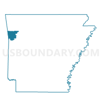
Outline

Summary
| Unique Area Identifier | 526275 |
| Name | Locke Voting District |
| County | Crawford County |
| State | Arkansas |
| Area (square miles) | 22.09 |
| Land Area (square miles) | 21.96 |
| Water Area (square miles) | 0.12 |
| % of Land Area | 99.45 |
| % of Water Area | 0.55 |
| Latitude of the Internal Point | 35.66654900 |
| Longtitude of the Internal Point | -94.09463630 |
Maps


Graphs
Select a template below for downloading or customizing gragh for Locke Voting District, Crawford County, Arkansas


Neighbors
Neighoring Voting District (by Name) Neighboring Voting District on the Map
- Voting District 4-C, Franklin County, AR
- Bidville Voting District, Crawford County, AR
- Chester Voting District, Crawford County, AR
- J P Dist 3-C, Franklin County, AR
- Mountain Voting District, Crawford County, AR
- Whitley Voting District, Crawford County, AR
- Winfrey Voting District, Crawford County, AR
Top 10 Neighboring County Subdivision (by Population) Neighboring County Subdivision on the Map
- Mountainburg township, Crawford County, AR (1,998)
- Whitley township, Crawford County, AR (1,224)
- Chester township, Crawford County, AR (785)
- Locke township, Crawford County, AR (285)
- Black Oak township, Franklin County, AR (158)
- Miller township, Franklin County, AR (109)
- Winfrey township, Crawford County, AR (61)
- Bidville township, Crawford County, AR (60)
- Shores township, Franklin County, AR (9)
Top 10 Neighboring Unified School District (by Population) Neighboring Unified School District on the Map
Top 10 Neighboring State Legislative District Lower Chamber (by Population) Neighboring State Legislative District Lower Chamber on the Map
- State House District 87, AR (30,579)
- State House District 83, AR (29,916)
- State House District 84, AR (25,531)